| Card n. | Description | Locality | Linked sites |
| 40 | La Stanga power station and village | Sedico | 127 - 89 |
| file .pdf | Contemporary Architecture (AC) | Google maps |
 |
 |
 |
- Description
- How to get there
- Interesting facts
- Bibliography
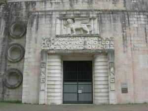
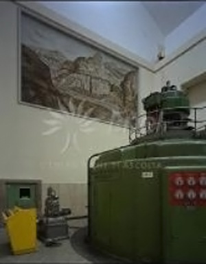
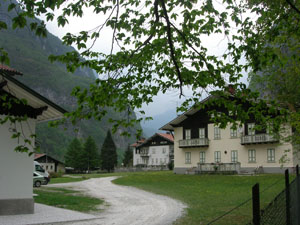
Along the provincial road that runs from Belluno to Agordo is the entrance to the “La Stanga” hydroelectric plant, the only visible part of a structure built entirely underground. The plant was part of the wider plan to exploit the middle section of the Cordevole, studied by the SADE in view of the growing demand for electrical energy of the village. In 1942 the architect Giuseppe Berti’s design for the striking façade, covered in blocks of pink stone, featured three large portals containing the transformers, and a side entrance topped by a carved lion of St. Mark and a Latin inscription that reads “The force of the rushing water, controlled by human skill, generates light and life”. The internal tunnel that leads to the machine room, equipped with two Francis turbines, is slightly uphill and is enhanced by splendid lamps that over the years lit up the room also during the annual parties frequented by staff and their families, as well as the local authorities and company managers. Just downstream from the plant, on the opposite side, is the village that was home to the plant workers, composed of six buildings, including a school. Also part of the village is the Church of Santa Barbara, built in 1942 by the architect of Armenian origin, O.L. Gurekian.
From Belluno, follow la SR203 Agordina until km 14.0, where you can see the ENEL village on the left of the road; after 500 m, on the right of the regional road, you can see the stone portal of the power station; on the left are the buildings and the area with the connecting and disconnecting switches, as well as the high voltage transport network.
ACCESSIBLE: from the outside
MUNICIPALITY: Sedico
PLACE: La Stanga
GEOGRAPHICAL COORDINATES: X 1740970 – Y 5123205
PROVINCE: Belluno
FILE COMPILED BY: Guadagnin
The Val de Piero is a narrow gorge through which runs the brook of the same name; along it we can see an interesting cave that faces onto the “principe Umberto” waterfall. CAI route no. 502 winds its way right along the Burel chasm, becoming a via ferrata on the final stretch before crossing the Oderzo Saddle at an altitude of 1716 m and then going down to the 1490 m altitude of the VII° Alpini refuge, dedicated to the fallen of the Belluno regiment it is named after. Inaugurated on 23 September 1951, this is one of the oldest mountain refuges in the Valbelluna, and replaced an old rural stone building at the foot of the Schiara and Gusela del Vescovà. Along the peaks of the Schiara, numerous vie ferrate were created over the following years (Zacchi, Berti, Màrmol, Sperti), thus forming, from 1961 the Alta Via no. 1 high mountain route, publicised by one of its creators, P. Rossi, and abroad by T. Hiebeler.
The CAI route no. 502 is a challenging mountaineering alternative to the more classic, direct approach route to the refuge that is generally followed from Belluno, Bolzano bellunese, Case Bortot, the Mariano bridge and CAI path no. 501 from the south side, along the upper section of the flow of the Ardo.
G. Arrigoni, Per i cinquant’anni del rifugio VII Alpini, in Le Dolomiti, year XXIV (2001) no. 1
ENEL, Gli impianti idroelettrici tra il Piave ed il Brenta, Vittorio Veneto, 1993
Alpago Novello, M. De Zorzi, Il tempo e l’architettura delle centrali. L’avvento dell’industria idroelettrica nelle Valli del Piave, Cordevole e Cellina, Degree thesis, academic year 1992-93
P. Rossi, SCHIARA, Guida dei Monti d'Italia CAI-TCI, Milan, 1982
