| Card n. | Description | Locality | Linked sites |
| 86 | Roman Bridge | Follina | 182 - 192 - 57 |
| Architecture Art History (ASA) |
Google maps |
 |
 |
 |
- Description
- How to get there
- Interesting facts
- Bibliography
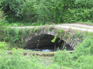
The stone bridge located at the point where the Soligo, Follina and San Pietro torrents meet, south of Follina old town, has ancient origins. The construction, depicted in a number of etchings by Canaletto, can easily be crossed despite the thick vegetation it is covered with, and leads to the entrance of Villa Brandolini. The bridge is believed by some to have been an integral part of an important Roman road system along the Via Claudia Augusta Altinate (1st century B.C.), while others maintain it was built during the reign of the Emperor Justinian (6th century A.D.). At the side of the bridge is a votive capital that was once located at the top of the arch of the bridge. Near Tre Ponti and Fornarette, the monks who colonised the area dug deep into the ground, allowing the waters of the rivers Soligo and Follina to flow freely, thus clearing the swamps in the area around the small hill on which is located the ancient abbey of Santa Maria di Sanavalle di Follina (182 HAA). The abbey complex is composed of the fourteenth-century church, the bell tower and the Romanesque cloister, completed in 1268, around which are the annexes used for monastic duties. It is the only abbey in the Veneto inhabited by Cistercian monks.
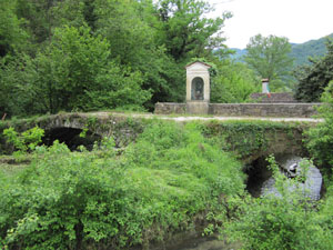
From the Vittorio Nord exit of the A27, continue on towards Vittorio Veneto and then take right onto the SP4 and drive to the centre of Follina. Along Via Circonvallazione the road ends in a roundabout that leads onto the one on the way out of the village, in Via G. Paoletti. Park near the roundabout with the petrol station on the right. The bridge is just a few metres away, indicated by the presence of a shrine and by two brick columns that mark the border of the surrounding lands.
ACCESSIBLE: yes
MUNICIPALITY OF: Follina
PLACE: Tre Ponti
GEOGRAPHICAL COORDINATES: X 1742150 - Y 5092810
PROVINCE: Treviso
FILE COMPILED BY: Bonato
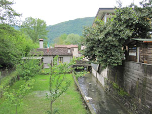
Near the “Roman” bridge is the crossing over the irrigation channel of the Follina torrent, used for centuries by the Paoletti wool mill (192 IA) where fulled wool fabrics continue to be produced to this day. The wool mill business was able to flourish in Follina and in the surrounding area thanks to the presence of suitable watercourses such as the Follina, Soligo, Corin and Fiadora torrents, and the name of the village appears to derive from the name of the torrent rather than the other way round. Numerous wool fulling plants operated here from the Middle Ages onwards.
The border between the provinces of Belluno and Treviso, i.e. between the municipalities of Mel and Miane, was once in the Val d’Arch, on a natural arch –the Volt (57 NS/ES) – that resembles a bridge, and bears an inscription repeated on both sides that put an end to the lengthy disputes triggered by ancient investitures and that symbolically and literally marks the border.
C. Rubini, E. Cipriani, Escursioni alto trevigiano, Verona, 2003
L. Cesca, Breve ricerca sulla località Tre Ponti di Follina, Follina, 2002
Various Authors, Il Veneto paese per paese, Florence, 1998
