| Card n. | Description | Locality | Linked sites |
| 7 | Salafossa And Argentiera Mines | Santo Stefano - S. Pietro di Cadore - Auronzo di Cadore | 119 |
| file .pdf | Industrial Archaeology (AI) | Google maps Salafossa - Argentiera |
 |
 |
- Description
- How to get there
- Interesting facts
- Bibliography
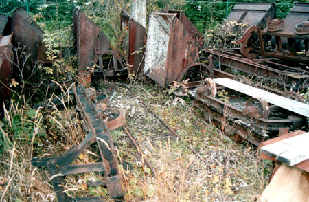
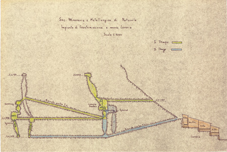
These are two sites, now abandoned, where lead – and later zinc - was once mined and processed, located on the banks of the rivers Ansiei and Piave and managed towards the end of their useful life by the Pertusola Company. The structure of both mines is now in poor condition, but they nonetheless represent a fine example of underground industrial archaeology, in particular the Salafossa mine. The mine itself and the few structures still intact of the Argentiera can be seen on the right bank of the Ansiei torrent, on the way out of the village north of Auronzo, while the Salafossa mines, where productivity was high from 1959 to 1986, are visible on the left side of the Piave, in the municipality of San Pietro di Cadore. In all likelihood, the Auronzo mine was already active as early as the Middle Ages, considering that the earliest documented licences were compiled using the Germanic methods. However, there was also active interest in the mine on the part of both the Republic of Venice and of private firms such as the Austrian Erario Montanistico until 1860, as well as the Angherer and the Società Montanistica of Sagor (Ljubljana). The waters of the Ansiei were used for washing the material extracted, before it was crushed and separated. The characteristic feature of the Comelico mine was the processing carried out in the galleries; barely visible today are the enormous chambers carved out in the rock that allowed the deposit to be almost completely exhausted.
From Santo Stefano di Cadore, head towards Sappada on the SR355, until about 1.65 km after the village of Presenaio, opposite the bridge over the Piave – road for the Val Visdende.
From Auronzo di Cadore, head towards Misurina on the SR48 to km 147.75, which leads to the San Marco or Somadida woods, near the hydroelectric power plant of Somprade.
ACCESSIBLE: the structures are both visible from the roads facing them; the entrances and the area of the mines can be reached on foot, although this is not recommended.
MUNICIPALITY: Auronzo di Cadore – Santo Stefano di Cadore / San Pietro di Cadore
PLACE: Somprade - Presenaio
GEOGRAPHICAL COORDINATES: Salafossa X 1776239 – Y 5164481. Auronzo Argentiera X 1755921 - Y 5161378
PROVINCE: Belluno
FILE COMPILED BY: Antoniol
In the centre of Auronzo Palazzo Corte Metto has recently been renovated and equipped to host the Flora, Fauna, Mineralogy and Archaeology museum, a number of panels of which are dedicated to the historical mines of the Auronzo district – Argentiera, Pian da Barco, Grigna and Ferrera.
S. De Vecchi, La miniera dell’Argentiera in Auronzo di Cadore in Archeologia industriale nel Veneto, Venice, 1990
A. Cecchi, La miniera di Salafossa, in L’industria Mineraria, 1988, n.1, pages 33-39
