| Card n. | Description | Locality | Linked sites |
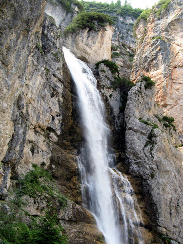
| 17 | Fanes waterfall | Cortina d’Ampezzo | 111 |
| file .pdf | Naturalistic Interest Sites (SIN) | Google maps |
 |
- Description
- How to get there
- Interesting facts
- Bibliography
The Fanes waterfall is located in an area where the geological, geomorphological and hydrological aspects typical of the Dolomites are revealed in all their splendid glory. The Val di Fanes area lies within two separate natural parks: the Dolomiti d’Ampezzo Regional Park, run by the Regole institution, spread over an area of 11,200 hectares north of the centre of Cortina, and the Fanes Senes Braies Natural Park in the South Tyrol. The entire flow of the Fanes brook is spectacular, on account of the large amount of water, which forms a continual succession of leaps and rocky ramps on the bed. With its gullies and canyons, this area offers some truly splendid scenery, and it is here, amid the steep slopes, that we find the highest waterfalls in the Dolomites, some 90 metres high. After the three consecutive falls, the Fanes brook runs into the Travenanzes brook, and the huge amount of debris that is gradually worn away and carried along by the current then settles on the vast flood plans of Pian de Lóa and Pian de Fiames. In the rushing, crystal-clear waters, the only fish species that lives and breeds successfully is the brown trout (Salmo trutta ssp. fario), which can often be seen swimming around in the eddying pools below. Alongside the waterfall, a pioneering type vegetation can be found, composed mainly of moss, while in order to admire a lusher, wider variety of plants, all you have to do is take a look at the areas close by. In the upper part of the Boite Valley, also worth a visit are the ruins of the Castle of Botestagno, an ancient fortress perched on the top of a rock above the Felizon torrent, from which there are ample views right out over the Ampezzo Valley.
You can leave your car in the car park at Pian de Loa (1364 m), just a few kilometres north-west of Cortina d'Ampezzo, on the road to Dobbiaco (SS 51). From km 109, follow the dirt road that runs alongside the Fanes Brook. From here, go along the CAI path no. 10, which leads to Ponte Alto (Ponte Outo), at 1460 metres a.s.l.
ACCESSIBLE: yes; may be visited
MUNICIPALITY: Cortina d’Ampezzo
PLACE: Fanes
GEOGRAPHICAL COORDINATES: X 1737734 – Y 5165270
PROVINCE: Belluno
FILE COMPILED BY: Nicoletti, Abordi, Cassol
In the Ampezzano area there were once several water-powered mills and workshops: a furniture workshop, an electrical power plant and a furnace built by the Apollonio brothers and the Regola sawmill at Pontechiesa.
M. Zanetti, Escursioni nelle Dolomiti d’Ampezzo, Caselle di Sommacampagna, 2004
ARPAV, Relazione annuale sulla qualità delle acque in provincia di Belluno
Formulario standard IT3230071 della rete Natura 2000
