| Card n. | Description | Locality | Linked sites |
| 23 | Cadore bridge | Perarolo di Cadore – Pieve di Cadore | 59 - 154 |
| file .pdf | Contemporary Architecture (AC) | Google maps |
 |
 |
- Description
- How to get there
- Interesting facts
- Bibliography
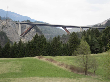
For centuries, road links with the Cadore area were ensured by routes that ran alongside Monte Zucco, such as the Cavallera road, which twisted and turned its way along the right-hand side of the Piave towards Tai di Cadore or, even earlier, by the Greola road, which set out from the covered bridge of S. Rocco sul Boite at Carsiè (north of Perarolo) and continued on to Valle di Cadore, following an ancient Roman route. The bridge, known as “Cadore”, built between 1982 and 1985, runs across the deep gorge formed by the river Piave, allowing for quicker links between the Canale road and the Centro Cadore area. Perarolo, which once was a central hub for the road and river transport system and a postal station on the Strada Imperiale Regia Postale road, was thus relegated to a marginal role, although the appearance of the town remained unchanged. This “Sfalassà” type frame bridge, composed of a system with inclined struts positioned in such a way as to give the metal structure a three-span continuous girder pattern, was designed by the Matildi engineering studio in Bologna, in steel and concrete. When it was built, it was the second highest in Europe, rising 184 metres above the bed of the Piave and with a clearance of 272 metres. This massive infrastructure commissioned by ANAS, which required some very delicate work and is part of the new route of the Alemagna trunk road, comprises a system of three viaducts with six, seven and eleven spans respectively, totalling 1150 metres in length and a maximum of 13 metres in width.
Come off the A27 motorway and continue towards the Cadore along the new Alemagna trunk road, and cross the Cadore bridge after the neighbourhood of Caralte on both sides of the River Piave. After the bridge you will enter the municipal area of Pieve di Cadore.
ACCESSIBLE: visible from the road
MUNICIPALITY: Perarolo di Cadore – Pieve di Cadore
PLACE: -
GEOGRAPHICAL COORDINATES: X 1759237 – Y 5144355
PROVINCE: Belluno
FILE COMPILED BY: Bonato/Vallerani
The old route of the SS 51 Alemagna trunk road runs past the Church of the Madonna della Salute (154 HAA) at Macchietto. This church was much loved by the Zattieri, or raftsmen, who were able to spot it on their way down from the Rrver Piave, or frequent it as they walked up each day towards Perarolo. Legend has it that one of the raftsmen, on his way past, struck with his angier (a tool for hooking up the trunks) the image of the Madonna conserved inside, ruining her eye, and that as a punishment he died on his raft on the Piave, precisely as he was passing Macchietto. The legend goes on to say that his son also lost his eye in an accident, as did all his relatives for seven generations.
W. Musizza, G. De Donà, Compie 25 anni il ponte Cadore, in “L’amico del Popolo” n.64, 12 December 2010
M.S. Guzzon, A. Guzzon, Cadore. Architettura & Arte, Padua, 2008
Various Authors, Il Piave, Verona, 2000
S. De Lorenzo, Il Centenaro di Valle di Cadore, Valle di Cadore, 1998
F. Zangrando, Perarolo di Cadore. Dal Cidolo al duemila, Treviso, 1990
