| Card n. | Description | Locality | Linked sites |
| 26 | Castellavazzo cement works | Castellavazzo | 85 - 45 - 162 |
| file .pdf | Industrial Archaeology (AI) | Google maps |
 |
- Description
- How to get there
- Interesting facts
- Bibliography
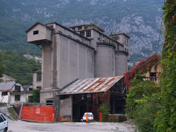
The striking concrete structure clearly visible north-west of the village of Castellavazzo, although empty and inactive, is an interesting sight. It is possible to identify two distinct areas: higher up is what was once the manufacturing plant, featuring the kilns, the crushers and a series of rooms used for related activities, while lower down we can see the more recent industrial premises, including the system of mills, the forwarding offices and a number of warehouses for storing clinker bricks. The extremely unusual disposition of volumes is characterised by the connection of the masses, the raising of the heights and the complexity of the sections. The cement works, which were in operation from 1912 to 1966, were founded by the Società Calce Bellunese in Castellavazzo, in order to make it easier to find and quarry stone in the area. In the 1950s, as a result of the growing demand for cement for the construction of the numerous dams being built in the Belluno area, the incoming company expanded the facilities. The quarries the stone came from were located on the left bank of the Piave, above the village of Codissago, at Crepe, Mas and Pascoli, and they were connected to the cement works by cableways and narrow-gauge railways. In 1978 the works closed down for good, and the internal structures were dismantled.
From the A27 motorway exit, continue towards the Cadore; after the village of Longarone, at the side of the trunk road, you will see the village of Castellavazzo. After the bend with the rock bastion with the church at the top, there is a fork on the left with the old road that runs through the centre of the village. The entrance to the former cement works is straight ahead on the right, after the Vittorio Veneto – Calalzo railway line.
ACCESSIBLE: yes
MUNICIPALITY: Castellavazzo
PLACE: Castellavazzo, former cement works area
GEOGRAPHICAL COORDINATES: X 1754932 - Y 5131515
PROVINCE: Belluno
FILE COMPILED BY: Antoniol
The centre of Castellavazzo (45 HAA) overlooks the narrow gorge at the bottom of which flows the Piave, which broadens out considerably from here onwards. It was once an important fortified outpost on the road that linked the area to the Cadore, as well as an important centre for the quarrying and working of rock of sedimentary origin that is known throughout the Veneto as “Castellavazzo stone”, and to which the local Stone and Stone Carving Museum is dedicated. In the central square is a large octagonal fountain (162 HAA), built in 1820 from sculpted Castellavazzo stone, and not far from the cement works can be seen the remains of a triangular lookout tower known as “La Gardona”.
In the neighbourhood of Podenzoi there are numerous washtubs and brent drinking troughs for animals, made from the same local marble.
Ivano Alfarè in S. De Vecchi, Opere nel Tempo-le tradizioni dell’industria e dell’artigianato tra i monti della Provincia di Belluno, S. Giovanni in Lupatoto, Verona, 1991
