| Card n. | Description | Locality | Linked sites |
| 31 | Muda Maè cemetery | Longarone | 124 - 66 |
| file .pdf | Contemporary Architecture (AC) | Google maps |
 |
 |
- Description
- How to get there
- Interesting facts
- Bibliography
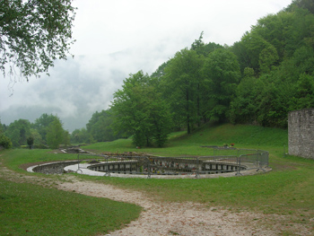
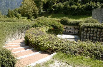
The new cemetery of Longarone lies in a flat area at the mouth of the Val Zoldana, on the right of the Maè torrent. The construction, a departure from the classic style typical of cemeteries, consists of a long, carefully structured route entrenched between walls built throughout in local stone. The solution adopted is both simple and original, and if we read through the correspondence between the architecture studios involved in the project, a number of suppositions can be made. It appears that a joint decision was taken on the solution to be adopted in the late spring of 1966 by the architects Gianni Avon, Francesco Tentori and Marco Zanuso, and that the project was then developed in Milan, after which the working drawings were drafted, modified and amended in Udine, during the lengthy period that preceded the actual construction in 1972. The decision to give the cemetery a low profile, the intention to make it an understated element in the surroundings, in a style that was closer to rural traditions than urban standards appears, according to Luppi and Zucconi, as a sort of tacit compensation owed to those who had been the “victims” of an excess of design criteria. A convenient stretch of tarmac road and a path link the Muda Maè cemetery with the one built for the victims of the Vajont disaster, at San Martino, Fortogna.
From the A27 motorway exit towards Longarone, take left for the Val di Zoldo along the SP251. The road that leads to the cemetery takes off from the provincial road at the fire brigade headquarters in Longarone, in Via Arduino Polla; after about 400 metres keep right and go down along the tarmac road towards a bridge over the Maè at Muda, and 400 m further along you will come to the cemetery (follow the road on the left).
ACCESSIBLE: yes
MUNICIPALITY: Longarone
PLACE: Muda Maè
GEOGRAPHICAL COORDINATES: X 1754344 - Y 5128458
PROVINCE: Belluno
FILE COMPILED BY: Guadagnin
Continuing along the road towards the Val di Zoldo, visitors can see the water-powered mills of Soffranco (66 ES). Rugged ground on the edges of pastureland and woodland leads to the mills used for grinding cereals and barley since 1880. The mills, which served the whole municipality up until the early Sixties, are now in poor condition. Nearby, there are some splendid views and landscapes characterised by the presence of water.
VARIOUS AUTHORS Sentieri facili, Comunità Montana Cadore Longaronese Zoldo, 2008
F. Luppi, G. Zucconi, G. Avon. Architetture e progetti 1947-1997, Marsilio
