| Card n. | Description | Locality | Linked sites |
| 30 | Pontesei dam and power plant | Forno di Zoldo | 143 - 126 -103 |
| file .pdf | Industrial Archaeology (AI) | Google maps |
 |
 |
 |
- Description
- How to get there
- Interesting facts
- Bibliography
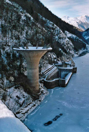
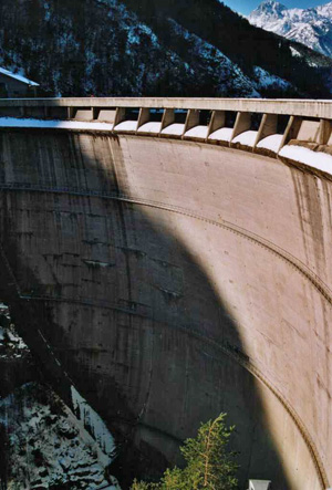
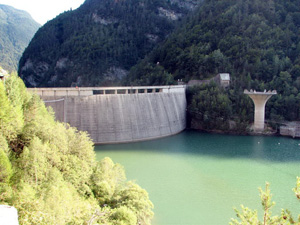
The Pontesei dam, together with those of Pieve and Valle di Cadore and the Val Gallina, is part of the system to fully exploit the waters of the Piave-Boite-Maè-Vajont rivers, the initial plans for which date back to 1939, and were developed and completed in the years thereafter. The Pontesei barrage on the Maè torrent was built between 1955 and 1957 and featured a particular 58.8 metre high chalice-shaped spillway. The dam appears in the same chapter of the modern history books as the Vajont disaster, due to the fact that on 22 March 1959, a landslide crashed down into the basin, 13 metres below the maximum height, causing a wave of around 20 metres high that swept away a worker from the construction firm. Below ground, on the left bank of the Maè, immediately downstream from the Pontesei dam, is the hydroelectric plant of the same name. All that can be seen today of the building, designed by the architect Gardella in 1958-60, is the façade, formed by a reinforced concrete wall, rough-hewn in horizontal lines and crossed with light-coloured stone stringcourses and Art Nouveau style decorative motifs.
From the A27 motorway exit towards Longarone, take left for the Val di Zoldo along the SP251. The road that leads to the power plant takes left towards the flow of the Maè torrent at km 116.5 after Solagnot, but it only reaches the point just below the reservoir.
ACCESSIBLE: from the outside
MUNICIPALITY: Forno di Zoldo
PLACE: Pontesei dam
GEOGRAPHICAL COORDINATES: X 1748408 - Y 5136480
PROVINCE: Belluno
FILE COMPILED BY: Antoniol/Guadagnin
The Maè torrent begins on the slopes of Monte Civetta, runs through a series of flood terraces in the high and middle sections of the valley, and after running through the narrow Canale ravine, flows into the Piave at La Muda di Longarone. The area around Mezzocanale is characterised by the presence of ravines (103 NS), in which the torrent passes between steep walls and suspended bridges, guaranteeing a spectacular sight.
Near Igne, you can cross the Maè torrent, thanks to a suspended metal walkway built in 1973 in memory of the cableway constructors of Igne and Soffranco, known throughout Italy for their technical skills.
C. Pavan, Le dighe e le centrali idroelettriche del bacino del Piave, Santa Lucia di Piave, 2001
A. Alpago Novello – M. De’ Zorzi, Il tempo e l’architettura delle centrali. L’avvento dell’industria idroelettrica nelle Valli di Piave, Cordevole e Cellina, IUAV – Degree Thesis, 1992-93
V. Fontana, Profilo di architettura italiana del Novecento, Marsilio Editore, 1999, pages 229-231
Società Adriatica di Elettricità Venezia, Impianti del Piave, Sistema Nord-orientale, Venice, October 1960, pages 31-33
