| Card n. | Description | Locality | Linked sites |
| 29 | Iron and nail Museum | Forno di Zoldo | 62 - 118 |
| file .pdf | Ethnographic Sites (SE) | Google maps |
 |
 |
- Description
- How to get there
- Interesting facts
- Bibliography
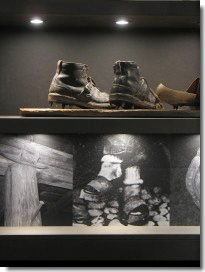
From the 14th century, a flourishing ironworking industry developed throughout the Val di Zoldo, the centre of which was Forno di Zoldo, to the extent that by the mid-sixteenth century the area could be defined the “iron valley”. Historical sources refer to iron forges, steel forges, iron and steel forges and simply forges, although it is difficult to clearly distinguish the different types from the scant amount of documents that have survived. The demographic crisis, the famine and the epidemics that swept through the valley during the 17th century all contributed to the decline in the metalworking industry, and from the 19th century onwards, the local labour force began specialising in the production of nails and shoe buckles, using old iron and waste iron. The once-large number of forges (used for the production of back iron and/or steel) and the fusinele (workshops for making nails and other types of utensils) had fallen to just one by 1950. Like the mills, the forges were found near watercourses such as the Prampera, the Moiazza, the Maè and the Mareson: many were swept away by the great floods or left abandoned, although many traces remain in the local area, especially in the place names and culture. Nails, elements of forges, tools, elements of hydraulic pumps, hitherto conserved in different sites, were gathered together in 2006 in the Iron and Nail Museum, set up in the former Palazzo del Capitano in Forno di Zoldo. The only workshop that has been reconstructed and can be visited in Zoldo is the fusinela of Pralongo on the Malisia torrent, inside which four forges can still be seen, although the ventilation plant and the hydro-eolic pump outside are no longer there. The ironworking process is illustrated through a collection of exhibits, some of which were recovered from among the gravel on the bed of the torrents.
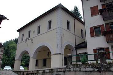
From the A27 motorway exit, head towards Longarone, then take left for the Zoldo valley along the SP251. Once you reach Forno di Zoldo, near the centre of the village, thereis plenty of parking; the museum is on the right, on a parallel road, Via S. Francesco, which sits slightly above the SP251 road, and is easy to recognise thanks to the sign outside and the characteristic portico.
ACCESSIBLE: yes
MUNICIPALITY: Forno di Zoldo
PLACE: Forno di Zoldo
GEOGRAPHICAL COORDINATES: X 1744519 – Y 5137461
PROVINCE: Belluno
FILE COMPILED BY: Barp/Antoniol
Until at least the 18th century, most of the minerals smelted in the furnaces of Zoldo came from the Fursil mines in Colle Santa Lucia, but thereafter, in the 19th century, only scrap iron and iron waste were used. Interesting mining sites in Zoldo were those of Medoli, between Dont and Sottorogno, on the right side of the Duran torrent, and, for lead minerals, the Valle Inferna (118 IA/ES), upstream from the abandoned village of Arsiera, where the openings to wells and galleries can still be spotted by the careful observer.
The waters of the Ru Torto or Ru Molinat, in nearby Zoppè di Cadore, were used to supply power to two mills, forges and sawmills.
R. Vergani, Peste e declino industriale in una valle alpina: la valle di Zoldo (Belluno) nella prima metà del Seicento in S. Cavaciocchi (a cura di), Le interazioni fra economia e ambiente biologico nell’Europa preindustriale secc. XIII-XVIII. Convention Papers, Florence, 2010
P. Lazzarin, B. Miot, G. David, Sentieri facili, Belluno, 2008
La via del Ferro tra Piave, Boite e Maè, Longarone, 2001
R. Vergani, Il piombo e il ferro in val di Zoldo in “Archeologia industriale del Veneto”, Venice, 1990
