| Card n. | Description | Locality | Linked sites |
| 33 | Soverzene power plant | Soverzene | 87 - 44 |
| file .pdf | Industrial Archaeology (AI) | Google maps |
 |
 |
 |
- Description
- How to get there
- Interesting facts
- Bibliography
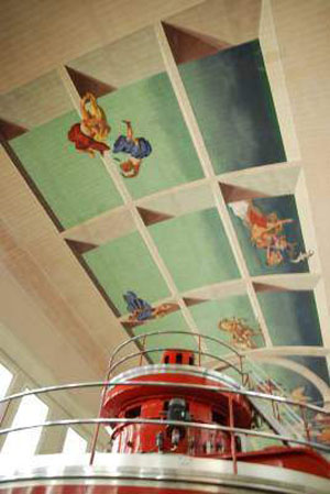
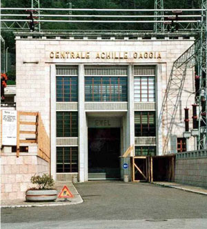
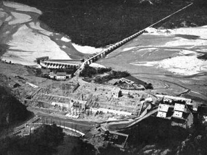
The Soverzene power plant, named after the engineer Achille Gaggia, one of the founders of the SADE, was once the most important of the hydroelectric plants on the Piave, Boite and Vajont. The plant itself, built in 1950, is situated in a 50 metre long tunnel through the mountain, while the outer parts are composed of the entrance area and the exedra that houses the terminal insulators of the outlet cables. The plant was devised by the two most famous technicians of the SADE, the engineers Semenza – who took care of the engineering aspects – and Mainardis, who took care of the electronic aspects; the architectural solutions were the work of the architect Mignozzi, who was also responsible for the carefully studied lighting of the underground parts of the plant, which were once controlled by staff day and night. Particularly interesting is the vault of the machine room, decorated by allegorical frescoes on the theme of electricity, exalting the force of the water, painted by the Feltre artist Walter Resenterra. Today the plant is powered by two interconnected retaining basins: the one formed by the barrage in Val Gallina for daily regulation and the one formed by the dam in Pieve di Cadore for seasonal regulation. The water from the power plant flows back into the Piave or the derivation channel that takes the water to Santa Croce lake to be used in the Fadalto plants. Behind the power station is the “Savi” mill, named after one of the local families, restored in 1990 by the electricity company ENEL, after years of abandon.
Immediately after the A27 motorway exit (Belluno Nord) towards Belluno, turn right into Pian di Vedova and follow the old SS 51 road until you come to a Stop sign; turn left, following the signs for Soverzene, and at the roundabout below, take the second exit and pass over the A27, then continue across the one-way bridge with the traffic lights.
After the bridge, at the first bend, you will find parking and the entrance to the power plant on the right.
ACCESSIBLE: from the outside only – guided visits can be booked
MUNICIPALITY: Soverzene
PLACE: Soverzene
GEOGRAPHICAL COORDINATES: X 1754722 -Y 5121658
PROVINCE: Belluno
FILE COMPILED BY: Antoniol
Dogna and Provagna (44 HAA) are two outlying neighbourhoods of Longarone, located along the road (a variant of the one on the opposite bank), that since 1808 have linked Codissago in the north with Soverzene in the south, on the left bank of the Piave. The orderly division of the land that characterises them would appear to indicate they are of Roman origin. Although the inhabitants were mainly employed in agriculture, along the banks of the river there were also a number of timber trade businesses. Setting out from Dogna is the “colomber” road, carved out into the rock in 1911-12 along the left side of the Vajont valley, used to link Longarone to Erto.
Vittorio Veneto Hydroelectric Business Unit, Centrali idroelettriche del Piave e del Cordevole, Vittorio Veneto, 2001
C. Pavan, Le dighe e le centrali idroelettriche del bacino del Piave, Santa Lucia di Piave, 2001
De Vecchi, La centrale di Soverzene in Archeologia Industriale nel Veneto, Venice, 1990
