| Card n. | Description | Locality | Linked sites |
| 34 | Andraz mills and forges | Livinallongo del Col di Lana | 73 - 134 - 133 |
| file .pdf | Ethnographic Sites (SE) | Google maps |
 |
 |
- Description
- How to get there
- Interesting facts
- Bibliography
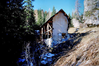
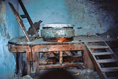
Andraz Castle once looked down onto the road that linked the upper part of the Cordevole Valley and the Val Badia, near the Falzarego pass. Around the castle we can still see traces of the industrial establishments that since the fourteenth century exploited the natural resources available locally. These establishments were essential to maintaining the site and meeting the needs of the garrison that presided the fortress during various periods. There are historical references to blast furnaces in use from 1334 to 1592, which recent excavation work carried out by the Superintendence Office has brought to light inside the courtyard of the castle, together with large quantities of minerals and waste material from the furnaces. Of the Catalan-style forge, all that remains is a wall with a ditch in front of it covered in refractory material, and a working platform in stone at the edge of the ditch. In the immediate surroundings of the castle, there is a better-preserved sawmill and a mill, of which we can still see both the wheel, fed by water from above, and the milling bench, with the mechanisms for the transmission of motion and the millstone for grinding cereals. In order to transport minerals from the Fursil mine on the slopes of Monte Pore to the processing plants in Caprile, Pescul, Zoldo and Val Parola, the bishop had a road built, the so-called “strada de la vena” or “strada del ferro”, a route at altitude that has recently been restored, where we can see houses, haysheds and water-powered sawmills. Initial processing of the material took place in the neighbouring valleys, after which it was forged in the fusine, or furnaces in the Agordo, Belluno, Zoldo and Bressanone areas to make top-quality blades for swords. In Selva di Cadore, the historical section of the “V. Cazzetta” Civic Museum (134 CA), given a new look in 2007, boasts a fine collection of documents referring to legal and border disputes regarding the use of the forests, pasturelands and mineral resources of the area.
From Belluno, follow the SR203 Agordina road; at Cencenighe, stay on the right and follow the SR203 in the direction of Alleghe-Caprile. From Caprile, continue along the SR203 into the municipality of Livinallongo del Col di Lana. At the crossroads with the SP48, keep right and follow the signs for the Falzarego pass and Andraz Castle.
ACCESSIBLE: yes
MUNICIPALITY: Livinallongo del Col di Lana
PLACE: Andraz
GEOGRAPHICAL COORDINATES: X 1728520 - Y 5151785
PROVINCE: Belluno
FILE COMPILED BY: Antoniol/Guadagnin
Andraz Castle (133 CA), a military outpost towards Venice pertaining to the Bishopric of Bressanone, is difficult to distinguish from the rocky mass it was built on. The structure, mentioned in a document dated 1177, signed by Federico Barbarossa in person, underwent various types of restoration and improvement work from 1484 onwards. In 2001, the Superintendence Office carried out conservation work designed to complete the protection and use of the structures: a reticular space structure supports the lightweight glass roof and a system of passageways for visitors, with steps and balconies, reaches up to the higher level, from which there are splendid views out over the valley.
M. Baldin, Il castello di Andraz e le Miniere del Fursil. Un itinerario storico culturale nelle Dolomiti, 1993
S. de Vecchi, Lavorare il ferro in provincia di Belluno, study material at the Seravella museum in Cesiomaggiore
