| Card n. | Description | Locality | Linked sites |
| 43 | Mis: Soffia Waterfalls and Cadini del Brenton Pools | Sospirolo | 107 - 161 |
| file .pdf | Naturalistic Interest Sites (SIN) | Google maps | 139 |
 |
 |
- Description
- How to get there
- Interesting facts
- Bibliography
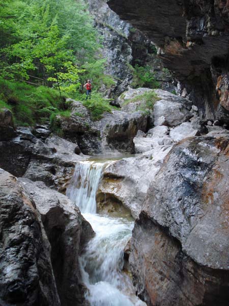
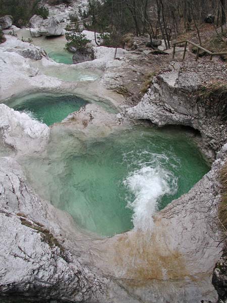
Mis Lake is an artificial body of water created by a dam built in 1962 at the village of Pascoli, as a reservoir for the production of hydroelectric energy. Near the lake you can admire two of the most spectacular geological formations in the Dolomiti Bellunesi National Park, representative of the powerful action of the water during the evolutions of these valleys: on the north-eastern side, the Soffia waterfall (107 NS), and on the north-western side, the Cadini del Brenton (161 NS). The spectacular leap of water, at the point where the Soffia torrent runs into the lake, is 12 metres high and is the result of an extremely lengthy process of hydrogeological evolution. The cadini, on the other hand, are fifteen pools formed by the swirling movement of the water in the Dolomia Principale rock. The pools vary in size from 60 centimetres to 4 metres and are connected to each other by numerous little waterfalls and slides.
From Belluno, take the SR203 to the village of Mas, and after the Mas bridge, follow the signs for Gron - Sospirolo. Once you reach Gron, go across the narrow bridge over the Mis and turn right. Continue until the little village of Mis, then turn left for Volpez and follow the tourist signs for the Mis valley. From those coming from the Feltre area along the SS51, after S. Giustina take left for Meano – Pregne, then proceed as above from the bridge over the Mis.
ACCESSIBLE: yes
MUNICIPALITY: Sospirolo
PLACE: Canal del Mis
GEOGRAPHICAL COORDINATES: X 1735220 – Y 5119294
PROVINCE: Belluno
FILE COMPILED BY: Nicoletti/Abordi/Cassol
At the end of the Mis Valley, on the road that runs from Sospirolo to Gosaldo, the village of California (139 IA/NS), grew up in the mid-nineteenth century around the hostelry of the same name. In this area, where human activity was virtually absent, the mercury mine of Vallalta was opened, and around 1870 was the sixth most important in Europe. California, after being lived in by the miners and frequented for a brief period by tourists, was completely swept away by the 1966 flood, and is today considered an area subject to hydrogeological risk.
P. Casanova, Una storia tante storie: la vita e la gente del canale del Mis, Belluno 1999
G.B. Pellegrini, Geomorfologia della valle del Mis
Il paesaggio nascosto, viaggio nella geologia e geomorfologia del Parco delle Dolomiti Bellunesi
