| Card n. | Description | Locality | Linked sites |
| 44 | Church of Santa Caterina | Ponte nelle Alpi | 16 - 157 |
| file .pdf | Architecture Art History (ASA) | Google maps |
 |
 |
 |
- Description
- How to get there
- Interesting facts
- Bibliography
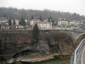
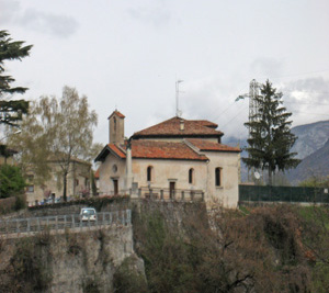
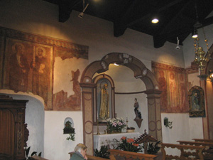
The building is at the entrance to the village of Ponte nelle Alpi, on a rock spur overlooking the River Piave, on the right-hand side. The church, mentioned in documents from the 14th century, is dedicated to Santa Caterina d’Alessandria, the protector of those who work with hydraulic energy; the saint, however, does not appear in the frescoes in the nave, part of which have been lost over the centuries. This is an important building, both for the fourteenth-century cycle of frescoes painted by travelling artists with knowledge of Venetian painting of the time, and for its attractive, strategic position, at a point where the Piave crosses a deep, narrow ravine before opening out into a wider valley. The wealth of individual pictorial decoration in the nave and on the counter-façade depict scenes from the life of Christ, as well as a number of saints, more recently joined by works by Maestro di Caorle, with features reminiscent of Giotto.
The little church can be reached from the A27 motorway exit for Belluno. After Cadola, at the roundabout, take the first exit in the direction of Cadore-Cortina, and just after the bridge over the Piave you will find the little square on the right with space for parking; the little church is clearly visible at the top of the rock spur.
ACCESSIBLE: from the outside; the inside may be visited upon previous booking, or during the Mass
MUNICIPALITY: Ponte nelle Alpi (Parish of Polpet)
PLACE: Santa Caterina
GEOGRAPHICAL COORDINATES: X 1753191 – Y 5119687
PROVINCE: Belluno
FILE COMPILED BY: Lonzi
Ponte nelle Alpi, known as Capo di Ponte until 1867, has always played an important role in the road and rail system of the Belluno area, because it was virtually compulsory to pass through the village on the way towards Belluno, the left bank of the Piave, Alpago or the Treviso area. The rafts and the tree trunks coming from the north along the Piave had to pass through the nearby Port of Cadola, where duties had to be paid, and the place’s history is closely intertwined with that of the Piave, over which a bridge was built several times there, referred to in a document from as far back as 1181. An interesting drawing from 1784 appears in the margin for a licence for the use of water in Polpet for three mill wheels, attesting to the presence of a covered walkway over the river. The present-day bridge, opposite the Church of Santa Caterina, was rebuilt in cement with a single-span structure after the First World War.
At the bend of the Piave there is an area of geological interest visible from the bridge or the church and accessible from the flood plain, downstream from the ravine. It is composed of an interesting rocky outcrop created by an ancient glacier, formed by scaglia rossa limestone rock and other geological formations, which acts as a natural threshold of the river. (157 NS IA)
M. Mazza, Tesori d’arte nelle chiese del Bellunese, Alpago e Ponte nelle Alpi 2010
Pro Loco Tourist Association of Ponte nelle Alpi, Guida di Ponte nelle Alpi, Grafiche Longaronese, Longarone,1995
D. De Pra, La decorazione ad affresco delle Chiese di Santa Margherita di Salakena presso Laggio di Cadore e di Santa Caterina a Ponte nelle Alpi, 1990
F. Pellegrini, Notizie storiche su Ponte nelle Alpi, Ponte nelle Alpi, 1985
F. Zalivani, Storia di Polpet e di Ponte nelle Alpi, Tipografia Piave, Belluno, 1984
G. Dalla Vestra, I pittori bellunesi prima dei Vecellio, Cassa di Risparmio di Verona, Vicenza e Belluno, Verona 1975
