| Card n. | Description | Locality | Linked sites |
| 55 | Fol area along the Ardo | Belluno | 5 - 106 |
| file .pdf | Ethnographic Sites (SE) | Google maps |
 |
 |
- Description
- How to get there
- Interesting facts
- Bibliography
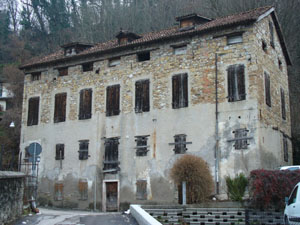
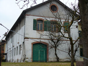
From the 15th century, when a large irrigation channel was created parallel to the flow of the Ardo, on the left bank of the torrent a series of small and medium-sized water-powered industrial establishments sprang up, which served the town of Belluno at least until the early years of the 20th century. Although today the channel runs underground and the hydraulic wheels have been removed, a number of buildings have maintained their original external appearance, while others have been converted for either public or private use, such as the De Luca Cultural Centre, which was once a tannery and a carpentry workshop. A report sent in 1574 by the then Podestà and Captain of Belluno, Miari, to the Doge of Venice mentions 28 establishments, with eleven mills, six hydraulic pressess, six forges, six sawmills for timber and three fulling machines. In the Fol area, just north of Borgo Prà, the Napoleonic Land Registry maps indicate the presence of two corn mills, a house with a machine for fulling wool, and a saw for timber. In the twentieth century, the largest building complex in the area was the tannery, clearly visible from the walking route that runs along the left bank of the Ardo. The path that sets out from Borgo Prà divides into two near the Church of San Francesco di Paola: on the left, it runs alongside the river, almost as far as the sluice gate, while on the right, the little road moves away from the bank and up towards Cavarzano, and from there to Fisterre.
From Via del Fol, take the pedestrian route to Borgo Prà, or viceversa, then Via San Francesco, near the new bridge, or from Borgo Prà.
ACCESSIBLE: yes
MUNICIPALITY: Belluno
PLACE: Fol
GEOGRAPHICAL COORDINATES: X 1748561 – Y 5115133
PROVINCE: Belluno
FILE COMPILED BY: Bonato/Eulisse
The Ardo torrent begins at the foot of Monte Schiara, in the heart of the Dolomiti Bellunesi National Park, and ends up in the Piave at Belluno. Along the 12 kilometre flow are a series of spectacular, deep ravines (106 NS), very interesting in terms of geomorphology, flowers and plants. The itinerary along the Ardo torrent, marked out a few years ago, comprises a stretch that runs through the town to Fisterre, a stretch at the foot of the mountains until Bolzano Bellunese and a path in the mountain that leads to Mariano.
M. Cassol, L. Facchin, Il torrente Ardo. Itinerario lungo il corso d’acqua dalla città di Belluno al Parco Nazionale dalle Dolomiti Bellunesi, Belluno, 1993
