| Card n. | Description | Locality | Linked sites |
| 70 | Val Canzoi | Cesiomaggiore | 158 |
| file .pdf | Naturalistic Interest Sites (SIN) | Google maps |
 |
 |
- Description
- How to get there
- Interesting facts
- Bibliography
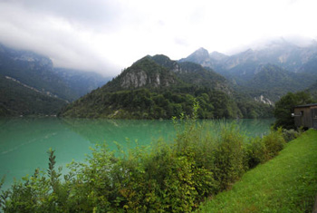
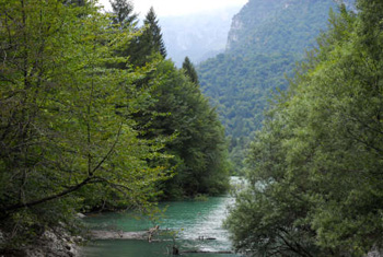
The Val Canzoi is one of the most attractive gateways to the Dolomiti Bellunesi National Park, and stretches from Preton to the La Stua lake in the north, on the right and left sides of the Caorame torrent over which a number of hydraulic power systems have been built. In the 16th century, the humanist Pierio Valeriano described the torrent thus: - “she flows hidden in a narrow, lofty little valley, and there are a number of dams built over it that raise the level of the waters, making it suitable for floating timber down”. Today, the long, spectacular valley boasts a wealth of superb natural environments, enhanced by the presence of small rural settlements and countless traces of the passage of Man through the area over the centuries. Scattered here and there are calchere, circular shaped lime kilns resting on the side of the mountain, partially below ground and completely open at the top, used until the 1950s to make lime. In addition to the Caorame, which shapes the landscape, the valley offers a large variety of humid zones: on the right is the spring, before the “de Foran” bridge, the small channels known as the lakes of Sant’ Eustachio and to the north is the artificial La Stua lake (1955), around which there is a circular trail with a series of information panels illustrating the main geological aspects and plant and animal species present in the area. There are various trails that set out from here, with a range of difficulty levels, so there is something suitable for every visitor. Setting out from the lake there are also two CAI paths, both of which are challenging: no. 806, which leads to the Cimonega hut and the Feltre-Bodo bivouac and takes over 4 hours, and the steep, uphill no. 802, which leads to the Piani Eterni and the Erera-Brendol mountain huts (with an interesting arched barn), in three hours.
To reach the Val Canzoi, go along the provincial piedmont road from Feltre towards Cesiomaggiore, and from Soranzen follow the tourist signs.
ACCESSIBLE: yes
MUNICIPALITY: Cesiomaggiore
PLACE: Val Canzoi
GEOGRAPHICAL COORDINATES: X 1727056 – Y 5110791
PROVINCE: Belluno
FILE COMPILED BY: Visentin
In Seravella di Cesiomaggiore visitors can explore the Ethnographical Museum of the Province of Belluno, which offers an overview of the various popular traditions of all the areas of the province, illustrated by a significant selection of exhibits of all kinds.
M. Cassol, D. Dal Zotto, Le vie dell’acqua. Alla scoperta di un territorio. Prealpi Bellunesi e Trevigiane, Belluno, 2007
Various Authors, Il Piave, Verona 2000
