| Card n. | Description | Locality | Linked sites |
| 78 | Castelnuovo di Quero | Quero | 31 - 52 |
| file .pdf | Architecture Art History (ASA) | Google maps |
 |
- Description
- How to get there
- Interesting facts
- Bibliography
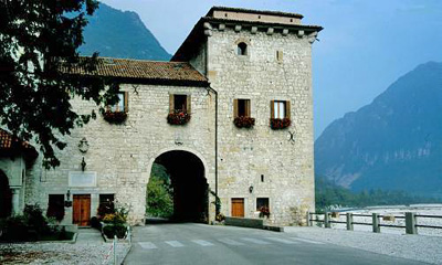
In the 16th century, Pierio Valeriano noted that “from Cesana it would be possible to sail until the mouth of the river without risk nor fear, were it not for the fact that four miles beyond Castelnuovo, over the wide bed of the river […] the promontory of Quero stretches out; this rocky headland, running diagonally to the current, forces it to turn back, forming a sort of amphitheatre”. The fortress of Castelnovo rises up over the narrow gorge of the Piave, and its original purpose was to control land and river traffic to and from the Treviso plain. Built in the 14th century for military and commercial purposes, it later became a palace-castle and today, with its original structure preserved intact, it is used as a place of prayer by the Somaschi Fathers, who purchased it in 1924. Castelnovo, or “new castle” is so called because the fortress replaced an earlier one situated further south, which was attacked and pulled down in 1196 by the militia of Gherardo de Taccoli, the bishop of Belluno. The present construction, one of the towers of which rests almost directly on the riverbed, was built by the Veronese captain Jacopo Crivelli for the Serenissima, who governed it until the fall of the Republic of Venice, sending castellans from noble families to rule over the parish of Quero for periods of two years. In the fortress lived Girolamo Miani, founder of the Somaschi Order and brother of Luca, superintendent of the Serenissima. Over the following centuries the castle changed hands and was ransacked on several occasions, suffering serious damage during WWI. The fortress is composed of a central building with a vault for carts and pedestrians to pass through, which was closed with a series of doors and access to which was across drawbridges. At the beginning of the sixteenth century, on the opposite (left) bank of the Piave, a tower was built to act as an outpost and for the purposes of laying out an iron chain to block the passage of rafts down the river. This tower was accidentally destroyed in 1885. In 2009 important restoration work began on the outside of the building.
The village, about 15 kilometres from Feltre, can easily be reached by taking the Feltrina SR348 road that runs to Treviso. At km 41, or at the neighbourhood of S. Maria (km 42.6), take the old road that lies slightly lower than the present-day road; continue alongside the railway line to the castle.
ACCESSIBLE: yes, from the outside; currently used for meditation
MUNICIPALITY: Quero
PLACE: Castelnuovo di Quero
GEOGRAPHICAL COORDINATES: X 1726573 - Y 5092186
PROVINCE: Belluno
FILE COMPILED BY: Visentin/Vallerani
On Col Maor di Quero, overlooking the Piave, is the German Military Memorial Chapel (52 HAA) designed in 1936-39 by the architect Robert Tischler, the resting place of 229 soldiers who belonged to the Alpenkorp and 3232 Austro-Hungarian soldiers killed during the First World War.
Bona, Breda, Pazè, Quero, dalle origini al XVIII secolo, Crocetta del Montello, 1990
B. Zanenga, Viaggio lungo Piave nel secolo 16: dalle Antichita bellunesi di Pierio Valeriano, Rome Casteldardo, 1966
A. Vecellio, I Castelli feltrini, Feltre, 1896
