| Card n. | Description | Locality | Linked sites |
| 93 | Falzè Boat Crossing | Sernaglia della Battaglia | 188 - 195 |
| file .pdf | Ethnographic Sites (SE) | Google maps |
 |
- Description
- How to get there
- Interesting facts
- Bibliography
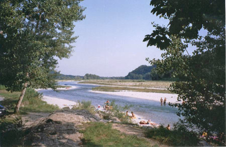
The Falzè boat crossing is on the left bank of the Piave, in the flood plain at the foot of the terrace above the river area, a few kilometres downstream from the humid zone of the Fontane Bianche di Fontigo. This area, very popular in summer and today equipped with picnic benches and tables, was an important port area in the late Middle Ages. Since the two banks are close to each other and the riverside area is gravelly, this was a suitable place for landing and crossing, before the narrow between Colfosco and Nervesa. Today it is no longer possible to distinguish the structures that once stood at the port, while in the adjoining area and along the access road it is possible to spot a few rural buildings and the towers of an old furnace. The port of Falzè grew in importance during the Serenissima, when the timber trade was the main economic activity carried out along the flow of the Piave and the rafts coming from Borgo Piave in Belluno moored here. Once their task was complete, the Belluno raftsmen headed back home to Follina and the Val Belluna, and the crafts were handed over to the crews of Nervesa. The ferry service, initially private, made river crossings possible from the 13th century, allowing the Collalto family to move between their old and new properties, and the service was not halted for good until 1970. A number of interesting routes, indicated in loco, set out from the port and lead into the floodplain area of the river.
The road that runs along the north-eastern side of the Montello can be reached by coming off the SR348 towards Crocetta del Montello and taking Via S. Anna along one of the branches of the Brentella Canal that crosses the town from north to south. South of Crocetta, turn left into Via Lodovico Boschieri, which near Borgo Santa Margherita goes onto the road that runs around the Montello woods. From Santa Mama, go up Via Vaccari on the right, then follow the tourist signs to the observatory. From the south side, go up Via Vaccari to Presa XVI. From the rest area at the top, continue for about 200 m on foot.
ACCESSIBLE: yes
MUNICIPALITY: Sernaglia della Battaglia
PLACE: Falzè di Piave
GEOGRAPHICAL COORDINATES: X 1745769 – Y 5082962
PROVINCE: TV
FILE COMPILED BY: Bonato/Vallerani
A further series of pleasant walks in an area rich in history and fascinating nature can be enjoyed in the strip of land near the Piave at Moriago, known as “Isola dei Morti” (195 HAA/NS). The name, meaning “island of the dead” derives from the bloody battles fought during WWI, in which many young men lost their lives, especially those at the forefront of the Italian army, the recruits born in 1899. These roads, named after Italian regiments, converge on an area where it is possible to visit the monument, the chapel designed by Alberto Alpago Novello, the commemorative stone and a series of wartime objects.
R.Spironelli, Falzè di Piave. Paese sul fiume, Pieve di Soligo, 2007
C.Rubini, E. Cipriani, Escursioni alto trevigiano, Verona, 2003
Various Authors, Il Piave, Verona, 2000
G. Caniato, La via del fiume dalle Dolomiti a Venezia, Verona, 1993
