| Card n. | Description | Locality | Linked sites |
| 97 | Papadopoli gravel beds and Madorbo ferry and hydrometer | Cimadolmo | 167 - 183 - 179 |
| file .pdf | Ethnographic Sites (SE) | Google maps |
 |
 |
 |
- Description
- How to get there
- Interesting facts
- Bibliography
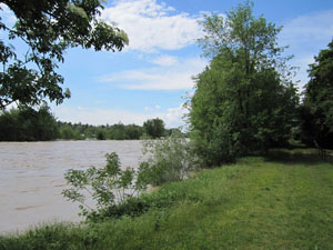
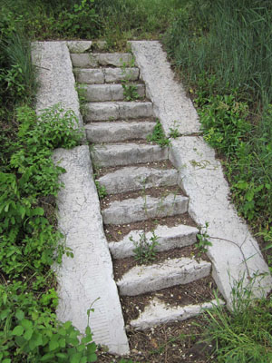
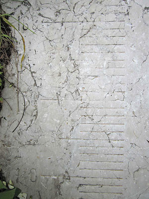
The Papadopoli gravel beds and the Madorbo flood plains have a very close relationship with the Piave: on the island formed by the gravel beds the river was an important resource, as well as marking the boundaries of the community; Madorbo, on the other hand, was linked to the activity of the ferry and the passage of rafts heading down towards the mouth of the river. The area of the gravel beds, although it is now well connected with the banks of the Piave by the two road bridges built in the 1970s, remains largely unspoilt and offers some very attractive views. The inhabitants of the small village on the island once made their living largely from growing grapes, asparagus and tobacco, although no trace of this remains today. The villagers were tormented by the erosion of the banks caused by the water, which they tried to stem using metal cages filed with pebbles. The earliest settlements in this area date back to Pre-Roman times, but the most significant contribution was made by the mediaeval monks who reclaimed the area and planted vines. Just downstream from the gravel beds of Papadopoli, where the branches of the Piave converge in a single riverbed, is Madorbo, where a ferry service ran from Roman times. The old landing stage was situated next to where the restaurant is today, and nearby you can see the abandoned lime kiln, as well as an Austrian hydrometer from 1832 that was used to measure the height of the river.
From the SP34 between Santa Maria di Piave and San Polo – on the left of the Piave – the SP92 takes off, linking up from the village of Tezze with Maserada, on the right of the Piave, crossing two bridges over two branches of the Piave that separate the area from the Papadopoli gravel beds.
ACCESSIBLE: yes
MUNICIPALITY: Cimadolmo
PLACE: Papadopoli gravel beds
GEOGRAPHICAL COORDINATES: X 1760348 - Y 5074016
PROVINCE: TV
FILE COMPILED BY: Bonato/ Vallerani
In San Polo di Piave is the castle-villa built for the noble Papadopoli (183 HAA) family, originally from the island of Candia, who moved to Venice in the 18th century. This Neo-Gothic villa, completed in 1865, was built in place of a turreted building erected on the orders of the patriarchs of Venice in the 15th century. Particularly interesting is the fourteenth-century Church of San Giorgio (179 HAA), once the parish church OF San Polo, which was extended on various occasions over the centuries and boasts richly decorated walls.
M.T. Furlan, Le grave di Papadopoli. Storia di un’isola sul Piave, Caerano San Marco, 2006
Various Authors, Il Piave, Verona, 2000
C. Falsarella, Cimadolmo. Guida culturale turistica e gastronomica del territorio comunale di Cimadolmo, 1999
