| Card n. | Description | Locality | Linked sites |
| 96 | Lovadina Raft Port | Spresiano | 187 - 184 - 164 |
| file .pdf | thnographic Sites (SE) | Google maps |
 |
 |
 |
- Description
- How to get there
- Interesting facts
- Bibliography
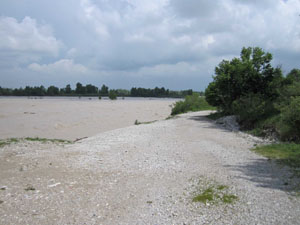
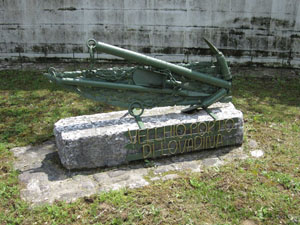
The Lovadina boat crossing, on the right of the Piave, was used since the early Middle Ages to link the banks of the river using boats. Important main roads once ran through the Lovadina area: the Via Claudia Augusta, during the Roman Age, and the Ongaresca, which linked Treviso with Friuli during the Middle Ages, until the Napoleonic road was built. The Ongaresca passed the Piave at the Lovadina crossing, but it is likely that the place was strengthened for defensive purposes since late Roman times, because it is indicated in documents as Castello di Piave or Passo della Torre. At the ferry crossing there was a hospice built around 1000, run by the Benedictine monks and later destroyed, like the Abbey of Santa Maria. According to a document from 1177, it was the abbey that ran the ferry service, indicated as navis transitoria. Today the historical landing stage is marked by a stone next to the First World War memorial.
One of the neighbourhoods that developed close to these main roads was Borgo Malanotte (184 HAA/ES), extended and enhanced in the 17th century by the Malanotte family from Trentino near the intersection between Via Tridentina and Via Ongaresca. The village, not far from Tezze sul Piave, is closed off to the south by the Piavesella canal. The property of the Abbey of Lovadina was administered for 50 years or so in the 16th century by the Bonotto family, who owned land around Borgo Malanotte until 1670.
Borgo Malanotte lies along the SP34 between Tezze-San Polo di Piave to the east and Ponte della Priula to the west. The group of buildings is located next to the new roundabout as you come out of Tezze.
The area of the Piave with the Lovadina wharf can be reached from the opposite bank of the Piave by following Via Barcador.
ACCESSIBLE: yes
MUNICIPALITY: Spresiano
PLACE: Lovadina
GEOGRAPHICAL COORDINATES: X 1755759 - Y 5075774
PROVINCE: TV
FILE COMPILED BY: Bonato/ Vallerani
Most of the nearby area of Breda di Piave, on the right of the Piave, is rich in springs, which form numerous rivers that run into the Sile, picking up ground water mostly from the aquifer of the Piave. This is the so-called “spring strip”, some 40 kilometres wide. The springs at Breda (164 NS) and in the surrounding area touch maximum depths of 1.50-1.80 metres, forming bubbles as a result of the gases dissolved in the water. The ground around the springs is soft and marshy in parts, rich in water throughout, making it ideal for numerous animal and plant species.
T. Zanchetta, Le abbazie del Piave: Santa Maria di Lovadina, Treviso, 2005
Various Authors, Il Piave, Verona, 2000
G. Simionato, A. Sartoretto, Storia millenaria di Lovadina, Treviso, 1981
