| Card n. | Description | Locality | Linked sites |
| 1 | Piave springs | Sappada | 99 |
| file .pdf | Nature Sites (SIN) | Google maps |
 |
- Description
- How to get there
- Interesting facts
- Bibliography
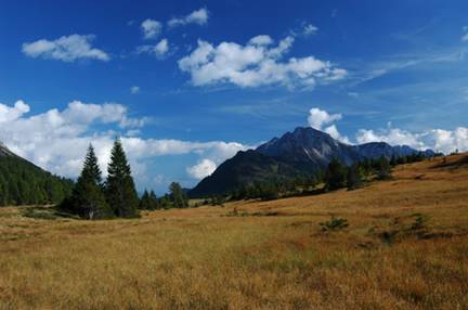
The springs of the River Piave are in Val Sesis (Zètz) at the foot of the white limestone massif of Monte Peralba, in an area with an altitude of between 1810 and 1939 m. a.s.l., with modest slopes, surrounded by areas of considerable landscape and environmental interest, characterised by a marsh area rich in source water and a mainly peaty area. The long-standing controversy between the two neighbouring areas of Comelico Superiore and Sappada over the source of the Piave was officially resolved in 1936, when the ministerial committee appointed for the purpose by the Military Geographical Institute decided in favour of the Sappada branch of the Val di Sesis, on the border with the Val Visdende. What there is no doubt about is the substantial biodiversity of the area (in terms of both plants and animals), the existence of a number of extremely rare, endangered species, and the presence of two biotopes, making the area along the northern and eastern sides of Col di Caneva particularly significant and therefore a protected area. A visit to the area is made especially interesting by the presence of a large variety of superb plants and animals, as well as by the particularly attractive landscape, with a wealth of springs and streams that ensure a constant supply of fresh water to support all the various life forms present. Near the Sorgenti del Piave refuge is a monument erected in memory of the vital role played by the river during the Great War, and there is a boundary stone indicating the place where the waters converge. The waters become a torrent only as they flow downwards, after picking up a number of small watercourses in the Val Sesis, before cutting across the village of Sappada.
From Santo Stefano di Cadore, follow the SR355 to Cima Sappada; go through the town centre, then take the asphalted SP22 that climbs all the way up the Val Sesis: the road is open to cars in the summer.
ACCESSIBLE: yes
MUNICIPALITY: Sappada
PLACE: Val Sesis
GEOGRAPHICAL COORDINATES: X 1784776 – Y 5170304
PROVINCE: BL
FILE COMPILED BY: Nicoletti/Abordi/Cassol
Among the exceptionally interesting plant species are the rare few-seeded bog sedge (Carex microglochin), few-flowered sedge (Carex pauciflora), round-leaved sundew (Drosera rotundifolia), bogbean (Menyanthes trifoliata) and arrowgrass (Triglochin palustre). The peat bogs provide ideal breeding conditions for a number of amphibians. A large variety of bird species are also present, such as the lesser whitethroat, the dunnock, the mealy redpoll, the black grouse and various types of tits, as well as a variety of small mammals and more common animals such as roe deer and foxes.
Various Authors, Nuova guida di Sappada / Plodn, Pieve di Cadore, 2010
C. Lasen, C. Argenti, Piano territoriale Provinciale della provincia di Belluno. Progetto Biotopo
File Natura 2000 IT 3230006
ARPAV Belluno, Relazione annuale sulla qualità delle acque
ARPAV Arabba Avalanche Centre, VARIOUS AUTHORS, Studio di 15 biotopi in area dolomitica
