|
|
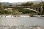
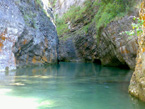
It is a passage, a passage in the Alps that splits valleys into two, dividing waters with their sources that spring to life from amid stones or moss, that emerge from snowfields as they melt; waters that find their way, find their voice, roaring their way into torrents, into rivers. Those rivers, however, all end up flowing into a sea, whether it be the Adriatic, the Tyrrhenian or the Black Sea. The waters of those two watersheds up there twist and turn at length through winding valleys, before dashing in thundering waterfalls into two major rivers. And then off those two fine, regal ribbons of blue flow, meandering their way gently through the hills, snaking their way gradually down into the fertile plains, sometimes bordered within lofty banks […]. These are sister rivers, slowly making their way back from different lands to the home from whence they set off.*
The words we have chosen to introduce this guide may not have been written to describe the Piave and the Drava , yet they are a perfectly appropriate portrait of the rivers and areas this guide will be looking at.
The rivers are the natural communication route that for centuries allowed for the circulation of people and ideas in the Italian-Austrian alpine area. Watercourses are all too often relegated to the role of administrative borders, and are not seen as basins conceived as a single unit, as encouraged by the European Water Framework Directive (WFD 2000/60).
The aim of the Interreg IV Drava-Piave project is to rediscover and enhance a common heritage, with architecture as a starting point. The area boasts a historical riverside and lakeside architecture with unique, unrivalled features that are not only not always adequately valued, but indeed in some cases lie in a state of abandon.
The Province of Belluno, as Lead Partner of the project together with the Province of Treviso, Verein Napoleonstadel-Karntens Haus der Architektur and the Tourist Association of Dobbiaco, has had the opportunity to analyse the characteristics of its own part of the hydrographical basin and to share its best practices with its cross-border neighbours.
The general aim is to promote sustainable ecotourism, thereby strengthening the sense of belonging and identity that binds together the peoples living alongside the rivers and thus improving the quality of their lives.
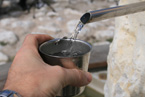
The activities promoted by the project lay the foundations for the development of a form of river tourism, linked with the concept of water as a "shared asset" that belongs to all of us, through deeper, more extensive knowledge of the area and the assets that remain connected to rivers or lakes.
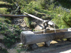
Particular attention is paid to quality architectures – alongside rivers or around lakes – as archetypes and prototypes of a way of living able to engage in a dialogue with the element water.
The project promotes a form of tourism aware of and attentive to the elements of our cultural and natural heritage that can be admired around the hydrographical basins of the two areas, providing ideas and suggestions for similar applications in other contexts of comparable landscape value.
Information is gathered, updated and stored, thus creating a record able to preserve the memory of water conserved by tradition – often oral tradition, sometimes documentary – in order for this heritage to be enjoyed in the future.
During the first phase required to gather information on the fluvial heritage of the Piave, the Centro Civiltà dell'Acqua (Water Civilisation Centre) relied on the collaboration of a scientific committee and a number of independent professionals.
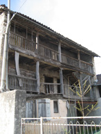
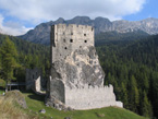
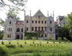
The committee of experts assisted the cataloguers in drawing up the list of the 200 sites considered significant from an architectural, naturalistic, ethnographical, historical, artistic and archaeological point of view for the fluvial heritage of the Piave basin.
The sites were identified and catalogued in view of their direct relationship with the river; the buildings for their functional and architectural features that could be linked to the use of water; the nature areas for their particular functional relationships with the river, with the water or with the context of the hydrographical basin.
The assets were first catalogued using a multi-disciplinary and interdisciplinary methodological approach and were then presented in such a way as to render the information accessible to a wide range of tourists.
The sites were originally divided up according to the theme(s) they were relevant to, so that five themed itineraries could be set out: nature, historical and artistic architecture, contemporary architecture, ethnographical interest and industrial archaeology.
This initial subdivision into assets belonging to the categories Contemporary Architecture (CA) Industrial Archaeology (IA) Historical and Artistic Architectures (HAA) Ethnographical Sites (ES) and Nature Sites (NS) has been maintained; assets catalogued as belonging to more than one category are presented in the prevalent one.
In drafting the guide, the authors decided not to set out the five itineraries initially planned, but to divide the hydrographical basins concerned into micro-areas, using geographical criteria rather than presenting them according to type.
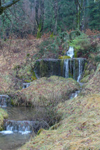
This geographical approach has the added advantage of allowing visitors to appreciate, to a varying extent depending on the area, the variety of themes present in each micro-area, thus providing clear evidence that, until the 1960s, the connection with water was a fundamental element of human activity, for everything from the transport of goods to the operation of mills, sawmills and steam presses, none of which would have been possible without the help and collaboration of water.
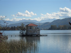
In the case of the Austrian partner, the Wörthersee lake becomes a place for reflection, the setting for villas to spend the summer holidays, where art and architecture create a smooth dialogue with the lake. The architects are called upon to engage with the lake and its waters, by creating wharves, shelters for boats, pergolas and terraces that face onto the banks nestling in the greenery or are built on rock spurs, in the Romantic style of the late nineteenth century. This vision has remained valid, and today's new architectures have the same relationship with the lake, although styles have changed in line with contemporary tastes.
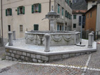
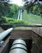
The Dobbiaco partner has created a network linking up a series of symbolic places that enjoy a direct relationship with water. An installation has been created to represent a maze, at the heart of which water springs from the ZweiWasserBrunnen fountain, offering a blend of waters from two different sources. There is a route that takes visitors along the various stages of the Drava, the Drava springs, an installation in the gardens of the Grand Hotel Dobbiaco, the belvedere platform at Dobbiaco lake, the Schmelze power plant, which harnesses the energy produced by the waters of the Rienza, and the ancient smelting furnaces of Klauskofel. All the work and the actions carried out as part of the project have made it possible to rediscover and recall to mind places and activities closely connected with water.
The micro-areas are divided up according to the different opportunities offered by the itineraries suggested, which make up a sort of "grand tour" to allow visitors to get to know the area better, or perhaps for the locals to discover elements they had forgotten or in many cases may never have been aware of. We hope that this initial, systematic work will bring back to light places that were frequently forgotten or abandoned once their relationship with water declined in importance.
This guide aims to be a clear, user-friendly resource for both local hikers and tourists, who will find information regarding the historical and natural aspects of the relationship between Man and water, which over the centuries has been divided up into a number of different sectors: water as motive power, water as a means of transport for timber, water as a source of hydroelectric energy, water as a tourist attraction to be enjoyed during holidays.
The Man - river relationship has today been largely replaced by the Man – road relationship, which offers different scenery, a different pace and different vehicles to travel on.
This method of cataloguing is aimed at presenting an alternative to the relationship described above, thus providing visitors with a better understanding of ethnographical shifts and technological developments in the architecture and art Man has created and preserved alongside the watercourses in this area of the Alps, today a UNESCO world heritage site.
Ivano Alfarè Lovo e Letizia Lonzi
--------
* Giovanna Zangrandi, in the introduction to the novel "I Brusaz" was describing the Piave and the Rienza, "border" rivers round which the story revolved. Near the Dobbiaco saddle spring waters that flow partly towards the Po and the Mediterranean (Rienza) and partly towards the Danube and the Black Sea (Drava). Although the destination reserved from them is different, both torrents have their roots in the Dolomities.
** The files of the Austrian and Dobbiaco partners have been rewritten by Ivano Alfarè Lovo, based on the texts provided by the Kärntnes Haus der Arkitectur in Klagenfurt and by Kathrin Tschurtschenthaler, manager of the Tourist Office of Dobbiaco. |
