| Card n. | Description | Locality | Linked sites |
| 4 | Pissandolo waterfall | Comelico Superiore, Ponte Pissandolo | 109 |
| file .pdf | Nature Sites (SIN) | Google maps |
 |
- Description
- How to get there
- Interesting facts
- Bibliography
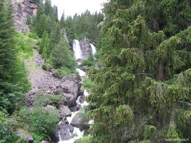
The Padola torrent, an affluent of the Piave that swells considerably with water just beyond the source, starts out north-west of the Monte Croce Comelico Pass, in a basin between the Frugnoni and the Montagna del Ferro, on the border between Comelico and Pusteria. As it heads south, the Padola dashes down a steep slope, surrounded by superb vegetation; this slope is known as the “Pissandolo waterfall”. The torrent, originally also called Grenzbach (border brook), can be divided into two similar, yet distinct classes: the first comprises the stretch that runs from the source to the intake of the Risena torrent, where no particular sources of pressure are evident, while the second continues along the course of the river till it joins the Piave, where it is used by hydroelectric plants. According to the plan for monitoring the surface waters, the torrent is nonetheless considered suitable for fish of the salmonoid family. At the sides of the Padola, upriver from the waterfall, there is a system of peat bogs that alternate as the amount of stagnant water varies, and are home to a large number of plant species, some of them rare. Examples can be found of the three types of peat bogs: soligeous, topogeneous and ombrogeneous, also known as low, intermediate and high. This leap of water creates a particularly striking effect that stands out amid the large stretches of surrounding forest.
From Santo Stefano di Cadore, take the SS52 trunk road and drive towards Comelico Superiore past the village of Padola; the waterfall can be seen at the side of the trunk road, at km 107.9, just before the Monte Croce Comelico Pass.
ACCESSIBLE: the waterfall is visible from the road, near the bridge of the same name
MUNICIPALITY: Comelico Superiore
PLACE: Pissandolo Bridge
GEOGRAPHICAL COORDINATES: X 1763290 – Y 5172534
PROVINCE: Belluno
FILE COMPILED BY: Nicoletti/Abordi/Cassol
As regards the Comelico Superiore area, at the foot of the Popera Group there are numerous alpine lakes: Orso lake, near the Monte Croce Comelico Pass, Rospi lake, Popera lake, Ciadin lake, nestling in the woods near the Lunelli refuge, Campo lake, north-west of the village of Padola, Ajarnola lake, at an altitude of 1597 m, S. Anna lake, at the edge of the road between Padola and Auronzo, and Cestella Lake, south east of the S. Antonio Pass.
I. Zandonella Callegher, M. Fait, Comelico e Sappada, Caselle di Sommacampagna, 2006
C. Lasen, M. Cassol, C. Argenti, Biotopi della Provincia di Belluno, Belluno, 1992
ARPAV, Censimento delle aree naturali minori della Regione Veneto
ARPAV, Rapporto sullo stato dell'ambiente provincia di Belluno
