| Card n. | Description | Locality | Linked sites |
| 36 | Digonera dam and spring | Rocca Pietore | 144 - 105 |
| file .pdf | Industrial Archaeology (AI) - Naturalistic Interest Sites (SIN) | Google maps |
 |
- Description
- How to get there
- Interesting facts
- Bibliography
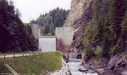
The construction of the dam began in the 1960s, and its purpose was to supply water, with another turbine, to the Saviner power plant. Work on it was brought to a halt, however, as a result of the concerns expressed by the locals following the Vajont disaster, and the dam was never completed. Still visible are a number of striking concrete structures, such as the buffer at the base and the pulvinos at the sides built right up to the crown of the dam. Also visible is the water uptake system, the spillway structure at the top, the bypass gallery and other secondary galleries, as well as the well of the lift mechanism for manoeuvring the floodgates, and the steel penstock upstream from the Savinèr power plant. At Saviner, along a dirt road in the gorge carved out by the waters of the Cordevole, it is possible to spot a sulphurous spring that has recently been sorted and equipped for tourist purposes.
From Belluno, follow the SR203 Agordina; at Cencenighe, keep right and follow the SR203 in the direction of Alleghe-Caprile. At Caprile turn left towards Rocca Pietore; the Saviner power station is on the right of the road, while the remains of the dam can be seen along the road that takes to the right just after the bridge over the Cordevole and runs along the flow of the torrent for 1 km.
ACCESSIBLE: yes
MUNICIPALITY: Rocca Pietore
PLACE: Saviner
GEOGRAPHICAL COORDINATES: X 1729511 – Y 5148253
PROVINCE: Belluno
FILE COMPILED BY: Antoniol
In the municipality of Rocca Pietore, between Malga Ciapela and Sottoguda, runs a deep natural gorge of about two kilometres long, carved out into the rock. The Serrai di Sottoguda (105 NS) is a large canyon that can be walked through, where steep rock walls surround and look down on a modest road at the valley bottom. The flow of the waters, which freeze in winter, forming spectacular ice waterfalls, help create a landscape that varies widely from season to season, while the plants, animals and other tourist attractions complete the appeal of the site.
C. Pavan, le dighe e le centrali idroelettriche del bacino del Piave, 2001
