| Card n. | Description | Locality | Linked sites |
| 48 | Sbarai Oasis at Santa Croce Lake | Farra d’Alpago | 104 - 140 |
| file .pdf | Naturalistic Interest Sites (SIN) | Google maps | 98 |
 |
- Description
- How to get there
- Interesting facts
- Bibliography
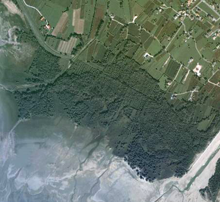
The Sbarai Oasis is a large humid zone on the north-eastern shore of Santa Croce Lake, considered one of the most important sites in the province for ornithologists, because of the number of migratory and sedentary species of water birds that spend the winter there. The area is characterised by fluctuations in the water level, which create different environments that are ideal for various species of plants. The birds that can be found there include the little grebe, the lapwing, the reed warbler, the sedge warbler, the penduline tit, the grey heron, the white stork and the long-tailed skua. Santa Croce lake, the largest natural basin lying fully within the Veneto Region, may have been formed as the result of a landslide that blocked the Val Lapisina fifteen thousand years ago, creating the Fadalto saddle and altering the original conformation of the river Piave. It is referred to in Pliny’s Naturalis Historia as lacus Piso, while during Roman times it was known as lapacinus or lapacinensis: the present-day name of the lake and of the church is believed to derive from the place where a cross (croce) marked the border between the diocese of Ceneda and the diocese of Belluno, an interesting indication of a Byzantine presence in the 7th century. The main influents of the lake are the Cellina channel in the north and the Tesa torrent, the main watercourse of the basin, which in 1817 destroyed the countryside around Farra and most of the houses.
From the exit for the Alpago along the A27 on the Fadalto Pass, continue until the Fadalto saddle. At the fork on the right, follow the signs for Farra d’Alpago; at the beginning of the village, after a small roundabout, turn left towards the large parking area at the lakeshore. From here, the dirt road runs first across the large wooden walkway over the Tesa torrent and then into the oasis.
From the opposite side, for those coming from the SS51, at the La Secca fork, continue in the direction of Puos-Farra; at the little village of Bastia, park in the small square, and after the regional road, continue on foot along the flat road, entering the oasis after crossing a small walkway across the Tesa Vecchio.
ACCESSIBLE: yes
MUNICIPALITY: Farra d’Alpago
PLACE: Sbarai Oasis
GEOGRAPHICAL COORDINATES: X 1758455 – Y 5113293
PROVINCE: Belluno
FILE COMPILED BY: Nicoletti/Abordi
With regard to the landslide phenomena linked to water that are a characteristic of the Alpago, it is also worth mentioning the 1300-metre-long draining tunnel (140 IA/CA), completed in 1996 after years of study and work, in order to diminish the amount of water that soaked into the landslide, keeping the ground in continual movement. Since, numerous landslides have come down from the slopes of Monte Teverone, reaching the edge of the village of Funes, in the direction of Lamosano.
On the opposite side of the lake, in Cornolade, a neighbourhood of Ponte nelle Alpi, the Maggiore Brook has carved out fascinating canyons (98 NS), with bends formed by low, winding crags, eroding the rock formed over the various epochs by the sedimentation of material deposits.
Various Authors, Itinerari per conoscere ed imparare. Guida naturalistica. Dal museo al territorio dell’Alpago, Interreg III project, 2004
Census of the minor natural areas in the Veneto region, ARPAV, 2003
M. Cassol, A. Dal Farra, Interessanti avvistamenti al Lago di S. Croce, Belluno, 1989
E. Stival, La pavoncella nel Veneto, 1989. E. Zanetti, Censimento della fauna acquatica nelle zone umide del Veneto 1987
I. Fossa, Pesci, Anfibi, Rettili, Uccelli, Mammiferi Bellunesi, Belluno, 1988
Trame, L’Alpago. Un popolo, una civiltà, un territorio, Belluno, 1984
C. Lasen, C. Argenti, - Piano Territoriale Provinciale della Provincia di Belluno: Biotopes project
Annual report on water quality in the Province of Belluno, ARPAV
Natura 2000 file IT 3230047
