| Card n. | Description | Locality | Linked sites |
| 49 | Mills of Puos and Bastia and "The roggia degli Edifizi" | Puos d’Alpago | 68 |
| file .pdf | Ethnographic Sites (SE) | Google maps |
 |
 |
- Description
- How to get there
- Interesting facts
- Bibliography
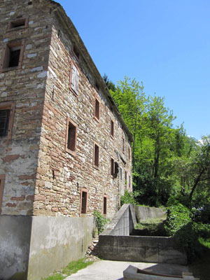
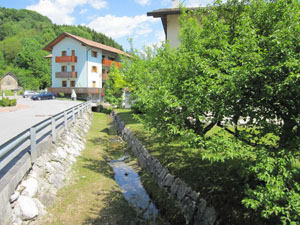
The most interesting water-powered industrial establishments in the Alpago area can be found in the centre of Puos and in Bastia, and were supplied by an artificial watercourse called “roggia degli Edifizi”, which began at Schiucaz, in the municipality of Pieve d’Alpago, and on the upper stretch powered a sawmill and a barley mill. Once it reached Puos, it supplied three hydraulic mills that are mentioned in documents from the sixteenth century. In the northern part of the village was the mulin de sora, the existence of which was mentioned for the first time in 1519 and which could count on two wheels for milling. Downstream from this first mill was the mulin de mezzo, the only one of the buildings still recognisable, which has now been converted into a home, with the wheel still visible and an irrigation channel below ground. It can be seen alongside the Funes Nova sawmill, which has now closed down. For a long time, the mill belonged to the Pluro family, and from 1580 onwards was equipped with a saw mechanism. Finally, at the former village dairy there was the mulin de sot, with two wheels and a saw. Along the channel, now completely underground, there were once also fulling machines, a steam hammer and a sawmill. Upstream from Puos, a branch came off from the irrigation channel towards the west, known as canale delle Pubbliche Seghe (public sawmills channel), because in the second half of the 18th century it began supplying water to the Bastia sawmills, which produced boards and strips of wood for the Arsenal in Venice. In the village of Bastia is the Caneve mill, an interesting three-storey construction that was once equipped with three wheels and a barley crusher. This mill, now in disuse, can be seen alongside the still-visible irrigation channel.
You can reach Puos along the SP422 from La Secca fork; at the Bastia roundabout, take the second exit towards Puos.
ACCESSIBLE: yes
MUNICIPALITY: Puos d’Alpago
PLACE: Puos d’Alpago
GEOGRAPHICAL COORDINATES: X 1758528 - Y 5114613
PROVINCE: Belluno
FILE COMPILED BY: Bonato
From the preparatory documents for the Austrian Land Registry drafted at the beginning of the 19th century, we know that there were very few water-powered mills in the Alpago besides the one in Puos: there was a mill in Chies, a two-wheel mill, a barley crusher and a sawmill at Garna, as well as three mills in Tambre, at least until the flood in 1825. (see E. Tonetti, Tesori d’arte Alpago, Belluno, 2010)
Various Authors, Il Veneto paese per paese, Bonechi, Florence, 1998
A. Collazuol, D. Da Vià, Puos d’Alpago. Aspetti di storia minore, Municipality and Pro Loco of Puos d’Alpago (BL), 1994
G. Caniato, La via del fiume dalle Dolomiti a Venezia, Cierre, Verona, 1993
Various Authors, L’Alpago raccontato da Umberto Trame. Un popolo, una civiltà, un territorio, Nuovi Sentieri, Belluno, 1984
