| Card n. | Description | Locality | Linked sites |
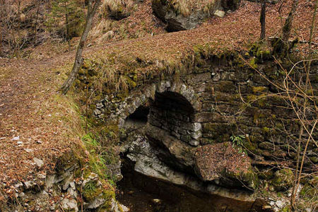
| 50 | "Roman" Bridge in Farra d'Alpago | Farra d’Alpago | 53 - 23 |
| file .pdf | Architecture Art History (ASA) | Google maps |
 |
- Description
- How to get there
- Interesting facts
- Bibliography
The single-span pedestrian bridge of Pianture, built entirely in stone, as well as the one over the nearby gorge, can be found along the “Alpago Natura” path, which touches upon Buscole and Pianture. According to as yet unpublished research by Mauro Vedana, the bridge, which crosses a small gorge on the Runal torrent, is one of the very few surviving elements of a road system used from the second half of the 13th until the end of the 14th century to travel from Udine to Belluno, without passing through Serravalle. The so-called strada del Patriarca, which runs from Friuli to Alpago, in the territory of Belluno […], regarding the route and age of which various hypotheses have been mooted, was a toll-free road that from Sacile climbed up the south-eastern hillsides of the Cansiglio before crossing Pian Cansiglio and linking up with the Alemagna road to la Secca, north of the lake. The bridge – probably of mediaeval rather than Roman origin - has survived in reasonably good condition to this day, although it is covered with a layer of earth and vegetation. It was probably used for the transport of military baggage wagons and goods.
The bridges can be reached by going along the tarmac road that comes up from the village of Farra from Buscole towards Spert. The church of the Madonna del Runal can be reached from the panoramic road that comes up from Farra towards Pianture. The road, asphalted at the beginning, later turns into a forestry path and today links back up even more clearly with Palughetto, at the beginning of the Cansiglio Forest, at the fork from Campon.
ACCESSIBLE: yes
MUNICIPALITY: Farra d’Alpago
PLACE: Pianture
GEOGRAPHICAL COORDINATES: X 1761591 - Y 5112191
PROVINCE: Belluno
FILE COMPILED BY: Guadagnin/Vedana
From the same path, it is possible to reach a hilltop from which there are fine views over the Alpago basin, and on which a church was built between 1864 and 1867. The church of the Natività della Beata Vergine del Runal, (HAA 23), built over an earlier eighteenth-century votive chapel, around which a number of legends have grown up regarding the location, can be seen on the edge of the Cansiglio forest, near the Runal torrent. The Runal road was the only route, albeit by no means an easy one, along which the timber could be brought down from the collection point at Palughetto to Santa Croce lake. In 1820, the inspector from the Belluno section of the State Property Office suggested that Runal may have derived from “ruinous”, as a result of the perils presented by the steepness of the route and the rainwater that flowed copiously down from the deep valleys. (A. Lazzarini, La trasformazione di un bosco. Il Cansiglio, Venezia e i nuovi usi del legno (secoli XVIII-XIX), Belluno, 2006)
L. De Martin e C. Rubini, Alpago e dintorni, Sommacampagna, 2001
G. Argenta, Vescovi di Feltre e di Belluno 1204-1462, Belluno, 1986
