| Card n. | Description | Locality | Linked sites |
| 65 | Meli sawmills and industrial establishments along the Lower Cordevole | Sedico | 122 - 20 |
| file .pdf | Industrial Archaeology (AI) | Google maps |
 |
- Description
- How to get there
- Interesting facts
- Bibliography
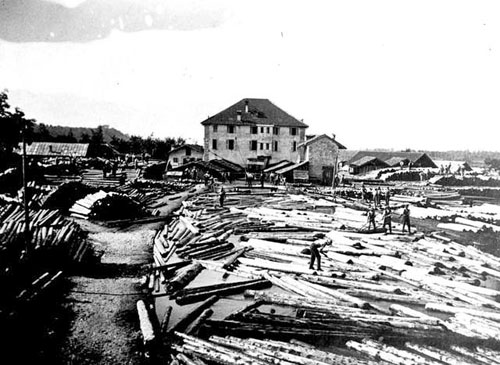
For centuries, along the flow of the Cordevole, between Roe Alte and the village of Bribano, there was an arm of water used to provide hydraulic power for a large number of establishments that have been exceptionally preserved, together with much of their more recent machinery, although all of them have now closed down. Parallel to the activity that went on along the flow of the Piave at Perarolo, here timber from the forests in the Agordino area and some of the valleys in Trentino was also floated down the torrent in individual trunks, before being channelled into the irrigation channels and sent to the sawmills, where the trunks were cut into saleable sizes, tied onto the rafts and sent down the brief navigable stretch of the Cordevole to the nearby Piave and from there to Venice. The Meli sawmills and the sawmills of Villa were the largest and most important of those built on the left bank of the Cordevole, but the earliest industrial establishments were presumably small and owned initially by local noblemen or landowners. Meli, which from the Middle Ages was home to mills, sawmills, forges, and more recently a paper mill, probably takes its name from the “lamelle”, the diminutive of the iron blades used to saw the tree trunks. Towards the far north of the route is the hydroelectric power plant, on the right bank, in the municipality of Sospirolo, and the ammonia factory, which did not close until 1968. The industrial archaeology site is part of a route that runs along the left bank of the Cordevole and features panels illustrating the most significant points of interest along the way.
From the SS50 Belluno – Feltre, you can reach the centre of Sedico; take the SR203 Agordina and continue per about 400 m, then turn left into Via Stadio or Via Cordevole. After about 600 metres, both reach a side road that runs in front of the large fenced area of the former industrial establishment, recognisable today as a result of the numerous roofs built to dry the wooden boards in the open air.
ACCESSIBLE: only from the outside, as it is now used as a private warehouse
MUNICIPALITY: Sedico
PLACE: Meli di Sedico
GEOGRAPHICAL COORDINATES: X 1738685 – Y 5110977
PROVINCE: Belluno
FILE COMPILED BY: Antoniol
In Bribanet, in the oldest part of the village, now cut in two by the railway, a little further down from the stone bridge, is the sixteenth-century church (20 HAA) dedicated to the patron saint of the raftsmen, San Nicolò. It was built on the orders of the Buzzati family, experienced ironworkers who owned land near the watercourses along which there were sawmills, mills and forges. The small building contains interesting works of art, including a polyptych by the painter Giovanni Agostino da Lodi, enhanced by a frame by Vittore Scienza. In the courtyard of the church is a boundary stone indicating the 1644 boundary between Meano and Bribano and therefore between the Feltre and Belluno areas, between which there were disputes over who should control the banks of the Cordevole. Until the bridge was built, first in wood and later in stone, a special kind of boat was used to cross from one side of the river to the other; this place was indicated on documents from the period as passo a barca, or boat crossing.
G. De Vecchi, Le antiche rogge lungo il basso Cordevole, Municipality of Sedico, 2009
S. De Vecchi, Le segherie dei Meli, in Archeologia industriale nel Veneto, Veneto Regional Council, Silvana Editoriale, 1990
S. De Vecchi, Opere nel tempo. Le tradizioni dell’industria e dell’artigianato tra i monti della provincia di Belluno, S. Giovanni Lupatoto, Verona, 1991
