| Card n. | Description | Locality | Linked sites |
| 67 | Santa Libera Mill | Santa Giustina | 69 - 38 - 26 |
| file .pdf | Ethnographic Sites (SE) | Google maps |
 |
- Description
- How to get there
- Interesting facts
- Bibliography
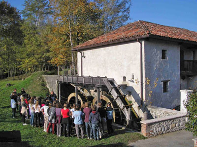
South of the village of Santa Giustina, along the Veses torrent, is a cereal mill that was operative until 1981; purchased and restored by the Municipal Council, it is now used for educational purposes. The two frescoes, in popular style, have also recently been restored: both can be dated to between the late nineteenth and early twentieth century, and depict, on one side, the Crucifixion, and, above the entrance, what has been identified as San Vinnoco, patron saint of the millers. The two wheels, which were set in motion by the irrigation channel, probably replaced an earlier two, documented as being in operation as far back as 1526. Over the centuries, the mill changed hands on various occasions, until the long period during which they were run by the Zanandrea family, who in 1972 raised the mill’s capacity to 12 quintals of grain and 12 of maize per day, making use of a leap of water 4.29 metres high. The two-storey building is situated in a typical rural courtyard, and is one of the stages on the cycling and walking routes along the irrigation channels of the Veses mapped out by the municipal council using European funding, within the framework of a project to enhance local culture. The Ignan-Salzan (or Molino) irrigation channel is the only one of the original three still in use, but along the Veses there were as many as 24 water-powered wheels that set in motion presses, millstones, mills, sawmills and machines for fulling cloth. The two tourist routes devised by the Municipality of Santa Giustina touch upon a whole series of buildings and industrial establishments of historical and ethnographical interest: one goes up from the bed of the Piave to Altanon, then takes off towards the Velos irrigation channel, while the other follows the flow of the irrigation channel of Formegan, along which were some of the 16th century forges known for specialising in the production of fine-quality iron swords.
Coming from Belluno (SP1), just before the parish church of Santa Giustina, turn left and go right along Via Piave until you come through the underpass. The building is in a rural courtyard at Salzan, on the left of the Veses, at the bend in Via del Molino.
ACCESSIBLE: yes (guided visits sometimes available)
MUNICIPALITY: Santa Giustina
PLACE: Salzan
GEOGRAPHICAL COORDINATES: X 1735840 – Y 5107312
PROVINCE: Belluno
FILE COMPILED BY: Antoniol
Not far from the Piave is Campo (38 HAA), another small neighbourhood of Santa Giustina, ideal for crop farming as a result of the even ground and the abundance of water present. Especially interesting here are the numerous public fountains and rural dwellings, arranged in the classic comb-like pattern typical of riverbank areas. In the surrounding area are a number of villas that mainly look onto the bed of the Piave, such as Villa Avogadro degli Azzoni at Salmenega (26 HAA), just downstream from Villa Zugni and Villa Zasio.
L. Bernard, Santa Giustina: i luoghi dell’acqua, Santa Giustina, 2006
D. Bartolini, Ruote ad acqua lungo il Veses. Storia e tecnologia, Santa Giustina, 2005
