| Card n. | Description | Locality | Linked sites |
| 63 | Pieve di Limana | Limana | 39 - 41 |
| file .pdf | Architecture Art History (ASA) - Ethnographic Sites (SE) | Google maps | 92 - 40 |
 |
- Description
- How to get there
- Interesting facts
- Bibliography
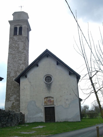
Until the 18th century, the centre of the Limana area lay just south of the present-day village centre, where the Limana and Refos torrents flow into the Piave. The Limana torrent represented not only a physical, geographical border, but also a political one, since it divided the areas of influence of the surrounding parishes. The small urban settlement grew up in a comb pattern along a main axis running parallel to the torrent and perpendicular to the Piave, with the main road reaching right down to the riverbank. The most interesting architectural elements present are the eighteenth-century Palazzo Trois, where the local council probably once met; the villa, once the home of the ecclesiastical authorities, dating back to 1670, and the church of Santa Barbara, one of the patrons of the raftsmen and the river folk and whom the locals prayed to protect them from lightning. Worth noting are the numerous washtubs and fountains present in this little hamlet to the left of the river. Pierio Valeriano, the parish priest of Limana during the sixteenth century, recalls that “after Limana is San Felice, where there is a ferry with boats moved along using only poles”, aplace also known as “Passo di barca di San Fis”. A little further north is the interesting little village of Praloran (41 HAA/ES), which differs from the typical form of the other groups of houses nearby, in that the operative centre of the country area was the manor house of the Barcelloni family, the external annexes of which were probably used as storehouses. The area that covers the hamlet of Praloran lies within an isosceles triangle, the sloping sides of which are the River Piave and the Cicogna torrent, and the countryside lying between the two watercourses is both very fertile and particularly subject to flooding when they overflow suddenly.
From the SP1 at Limana there are various roads that lead to Pieve di Limana; the most direct of these, along the route of the old road, is the one that from the roundabout before the entrance to Limana (second exit) goes along Via Papa Luciani and Via Bruno Carlin through the plains of the Piave. Those wishing to visit Cesa (40 HAA ES), another characteristic little village on the Piave, should take Via degli Alpini and head for the Costan factory.
ACCESSIBLE: yes
MUNICIPALITY: Limana
PLACE: Pieve di Limana
GEOGRAPHICAL COORDINATES: X 1743109 – Y 5108886
PROVINCE: Belluno
FILE COMPILED BY: Visentin/Vallerani
Val Morel (92 NS) is a valley in the municipality of Limana, sandwiched between the Limana and Cicogna torrents, left-hand side affluents of the Piave, where the writer from Belluno Dino Buzzati set his 1971 work “Miracoli di Val Morel”. The area has managed to maintain a number of natural and rural characteristics that have now been lost in other more frequently visited villages along the Piave.
S. Chiovaro, Ville venete: la Provincia di Belluno, Venice, 2004
I. Barattin et al., Ambiente, Storia e cultura di Limana, Feltre, 1995
B. Zanenga, Viaggio lungo il Piave nel secolo XVI. Dalle antichità Bellunesi di Pierio Valeriano, Roma – Casteldardo, 1966
